

Overview of the Niger River in Mali

The Niger River is the third-longest river in Africa, stretching approximately 4,180 kilometers (2,600 miles) across West Africa. In Mali, the river extends for about 1,700 kilometers (1,056 miles), making it the country’s dominant geographical feature. The river enters Mali from Guinea and flows northeast through the country before turning southeast toward Niger, Nigeria and eventually emptying into the Atlantic Ocean through the Niger Delta.
Mali contains one of the most unique sections of the Niger River – the famous “Niger Bend,” where the river makes a dramatic curve near the ancient city of Timbuktu. This unusual geography resulted from the joining of two ancient rivers over time. The upper Niger once emptied into a now-dry lake east-northeast of Timbuktu, while the lower Niger started south of Timbuktu and flowed into the Gulf of Guinea. Upstream erosion eventually led to the capture of the upper Niger by the lower Niger, creating the distinctive bend we see today.
The Niger River connects Mali to neighboring countries including Guinea (where it originates), Niger, Benin and Nigeria. This connection has facilitated trade, cultural exchange and shared resource management throughout history. Today, the Niger Basin Authority coordinates efforts among these nations to manage this vital waterway sustainably.
Key Cities Along the Niger River in Mali
- Bamako – Mali’s capital and largest city sits on the Niger’s banks, serving as the country’s administrative and economic center. The river provides transportation, water and electricity through the Sotuba Dam.
- Ségou – Known as the “city of mud cloths,” Ségou was once the capital of the Bambara Empire. Today, it’s an important agricultural center where the Markala Dam diverts water for irrigation.
- Mopti – Called “Venice of Mali,” this city sits at the confluence of the Niger and Bani rivers. It’s the center of Mali’s fishing industry and a major port where traditional pinasse boats gather.
- Timbuktu – This legendary desert city near the northernmost bend of the Niger was once a center of Islamic scholarship and trans-Saharan trade. Though now several kilometers from the river, it historically relied on the Niger for commerce.
- Gao – An ancient trading center and once capital of the Songhai Empire, Gao marks where the river turns southward after its great bend through the Sahel.
Geographical Significance of the Niger River in Mali

Agricultural Lifeline
In a country where much of the land is arid or semi-arid, the Niger River creates a fertile ribbon that supports Mali’s agricultural economy. The river’s annual flood cycle naturally irrigates farmland along its banks, allowing for the cultivation of rice, millet, sorghum and vegetables. The Inner Niger Delta, a vast inland delta covering about 30,000 square kilometers during peak flooding, is particularly productive.
The Markala Dam, located downstream from Ségou, diverts water to irrigate approximately 75,000 hectares of land in the Office du Niger scheme, one of Africa’s oldest and largest irrigation projects. This system has transformed the region into Mali’s breadbasket, producing about 40% of the country’s rice.
Transportation Network
The Niger River serves as a vital transportation artery through Mali, particularly during the high-water season from July to January. Traditional wooden boats called pinasses carry goods and passengers between riverine communities, while larger vessels transport bulk commodities like grains and construction materials.
The river is navigable from Koulikoro (about 60 km downstream from Bamako) to Gao during high water, a distance of approximately 1,400 kilometers. This waterway reduces transportation costs in a country with limited road infrastructure and no railways connecting many river communities.
Ecosystem Support
The Niger River sustains diverse ecosystems across Mali, from gallery forests along its banks to the expansive wetlands of the Inner Niger Delta. This inland delta, recognized as a Ramsar site of international importance, provides habitat for millions of migratory birds from Europe and serves as a critical breeding ground for fish.
The river supports over 130 fish species in Mali alone, sustaining both commercial and subsistence fishing communities. The annual flood cycle replenishes soil nutrients, maintains wetlands and supports the natural regeneration of vegetation, creating a mosaic of habitats that harbor biodiversity in an otherwise harsh environment.
Historical Importance of the Niger River in Mali

Cradle of West African Empires
The Niger River basin served as the heartland for several of West Africa’s greatest empires. The Ghana Empire (8th-11th centuries) controlled the western portions, while the Mali Empire (13th-15th centuries) expanded control along the river’s middle reaches. Under Mansa Musa, considered one of history’s wealthiest individuals, the Mali Empire reached its zenith with Timbuktu becoming a center of Islamic learning and commerce.
The Songhai Empire (15th-16th centuries) subsequently dominated the river basin, with its capital at Gao. These empires prospered by controlling trade along and across the Niger, collecting taxes from merchants and facilitating the exchange of gold, salt, slaves, textiles and other goods.
Trans-Saharan Trade Routes
The Niger River’s unusual northward bend brought it close to the southern edge of the Sahara Desert, creating natural termini for trans-Saharan trade routes. Cities like Timbuktu and Gao became wealthy entrepôts where goods from the forest regions to the south were exchanged for North African and Mediterranean products.
Salt from Saharan mines was traded for gold from forests to the south, with the Niger providing both transportation and the water necessary for desert caravans. This trade network connected West Africa to North Africa, the Middle East and indirectly to Europe, facilitating not just economic exchange but also the spread of Islam and scholarly knowledge.
Colonial Period and Independence
European exploration of the Niger began in earnest in the late 18th century, with Mungo Park becoming the first European to confirm the river’s eastward flow in 1796. The river’s course remained a geographical mystery until Richard and John Lander traced it to its delta in 1830.
During the colonial period, the French used the Niger as a transportation route into the interior of their West African territories. They established river ports and began irrigation projects, most notably the Office du Niger, started in 1932. After Mali gained independence in 1960, the river remained central to national development plans and regional cooperation.
Environmental Challenges Facing the Niger River in Mali

Desertification and Climate Change
The Niger River basin in Mali is experiencing accelerating desertification, with the Sahara Desert advancing southward at an estimated rate of 48 kilometers per year in some areas. This process is driven by a combination of climate change, deforestation, overgrazing and unsustainable agricultural practices.
Climate change models predict a 1.5-3°C temperature increase in the region by 2050, likely intensifying evaporation from the river and its wetlands. Rainfall patterns are becoming more erratic, with more intense but less predictable precipitation events. These changes threaten the river’s flow regime, which has already seen significant reductions since the drought decades of the 1970s and 1980s.
Pollution and Water Quality
Urban centers along the Niger, particularly Bamako, discharge untreated sewage and industrial waste directly into the river. Artisanal gold mining operations use mercury and cyanide, which contaminate river sediments and bioaccumulate in fish consumed by local populations.
Agricultural runoff containing fertilizers and pesticides contributes to eutrophication and algal blooms in slower-moving sections of the river. Plastic waste is an increasing problem, with debris accumulating along riverbanks and threatening aquatic life.
Dam Construction and Water Management
Several dams on the Niger River in Mali, including the Sélingué Dam on the Sankarani tributary and the Markala Dam, have altered the river’s natural flow regime. While these dams provide benefits like hydroelectric power and irrigation water, they also disrupt fish migration, trap sediments and reduce the beneficial flooding of downstream wetlands.
Proposed new dams, including the Fomi Dam in Guinea, could further impact Mali’s portion of the river, particularly the ecologically critical Inner Niger Delta. Balancing energy and agricultural needs with ecological requirements presents a significant management challenge.
Learn about the Aksumite Empire.
Cultural Aspects of the Niger River in Mali
Riverine Communities and Livelihoods
Several ethnic groups have developed specialized lifestyles adapted to the Niger River environment. The Bozo and Somono peoples are master fishermen who have developed sophisticated techniques and equipment for harvesting the river’s bounty. The Bozo in particular are known for their intimate knowledge of the river’s channels, fish behavior and seasonal patterns.
The Fulani (Peul) herders bring their cattle to the river’s floodplains during the dry season, practicing transhumance between the river and drier grazing lands. Agricultural communities like the Bambara have developed farming systems that take advantage of the river’s annual flood cycle, planting different crops as the waters recede.
Festivals and Traditions
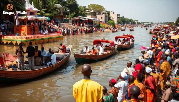
The river inspires numerous cultural celebrations throughout Mali. The most famous is perhaps the Festival sur le Niger in Ségou, which combines music, art and cultural exhibitions to celebrate the river’s importance. In fishing communities, ceremonies mark the beginning of fishing seasons, with sacrifices and prayers to river spirits for safety and abundant catches.
In Mopti, the annual crossing of cattle herds across the Niger is a spectacular event where thousands of animals swim across the river guided by Fulani herders. This practice, developed over centuries, represents the symbiotic relationship between the people, their livestock and the river.
Myths and Spiritual Significance
In traditional beliefs across Mali, the Niger River is often personified as a deity or spiritual force. The Bambara speak of Faro, a water spirit associated with fertility and creation, while Bozo fishermen perform rituals to appease water spirits before major fishing expeditions.
Many communities maintain sacred sites along the river where offerings are made during times of drought or flooding. These spiritual connections reflect the river’s fundamental importance to life in the region and embody generations of accumulated knowledge about the river’s behavior and ecology.
Conservation and Management Efforts

Facing mounting environmental challenges, various initiatives aim to protect the Niger River in Mali. The Niger Basin Authority (NBA), an intergovernmental organization comprising nine countries in the basin, coordinates transboundary water management and sustainable development projects. Their Sustainable Development Action Plan addresses issues like erosion control, water quality monitoring and climate change adaptation.
Local communities are increasingly involved in river conservation through participatory management approaches. In the Inner Niger Delta, community fishing agreements regulate harvesting practices to prevent overfishing. Reforestation projects along riverbanks help combat erosion and provide sustainable fuelwood alternatives to prevent deforestation.
International organizations like Wetlands International work to preserve the ecological integrity of the Inner Niger Delta through research, advocacy and community-based conservation projects. Their efforts focus on maintaining the natural flood pulse that sustains this crucial ecosystem while balancing human needs for water, food and livelihoods.
Appreciate Niger River Mali
The Niger River remains the lifeblood of Mali, weaving together the country’s past, present, and future. From sustaining ancient empires to supporting modern agriculture, from enabling transportation networks to nurturing unique ecosystems, its importance cannot be overstated. The river has shaped Mali’s cultural identity and continues to define its development possibilities.
Yet the challenges facing the Niger River – climate change, pollution and competing demands for its waters – require thoughtful management and international cooperation. As Mali and its neighbors work to balance human needs with environmental sustainability, the river’s health will remain a critical indicator of the region’s wellbeing.
For millennia, the people of Mali have adapted to the river’s rhythms, developing deep knowledge of its patterns and potential. This traditional wisdom, combined with modern scientific approaches, offers the best hope for ensuring that the Niger River continues to sustain life and livelihoods for generations to come.
Did You Know?
- The Niger River flows in a boomerang shape, initially heading away from the ocean into the Sahara Desert before turning southeast – a geographical puzzle that baffled European explorers for centuries.
- The Inner Niger Delta in Mali loses nearly two-thirds of its water volume to evaporation and seepage, yet still creates one of Africa’s largest wetlands.
- The river’s name likely comes from the Berber phrase “gher-n-gheren” meaning “river of rivers,” though local peoples have many different names for it, including “Joliba” (great river) in Manding languages.
Explore the Niger River in Mali
Discover more about this magnificent river with our comprehensive guide. Get detailed maps, seasonal visitor information and conservation updates to enhance your understanding of West Africa’s lifeline.
Share you River Niger views in the comments below.


Leave A Comment