

Raw power defines a waterfall’s true strength, not just its visual impact on observers. Angel Falls reaches an impressive height of 3,212 feet. Victoria Falls creates the largest sheet of falling water. The real measure of power lies in something different – the flow rate.
Inga Falls stands as the mightiest waterfall by volume with a flow rate of 25,768 cubic meters per second. This massive flow makes Niagara Falls look small, which moves 2,407 cubic meters per second. The list of powerful natural wonders includes more than visible waterfalls. The Denmark Strait Cataract flows underwater and moves an estimated 3.2 million cubic meters per second, making it maybe the world’s most powerful waterfall. The ranking examines fifteen remarkable waterfalls based on their unstoppable power rather than height or beauty. These range from Murchison Falls’ intense flow through a narrow 7-meter gorge to Iguazu Falls’ impressive 8,858-foot span.
Inga Falls

Image Source: Britannica
Inga Falls stands as the world’s most powerful waterfall. Its raw hydraulic force comes from massive water volume rather than tall drops. You’ll find this natural wonder on the Congo River in the Democratic Republic of Congo, where it moves water at rates that make other famous waterfalls look small.
Inga Falls Flow Rate
The falls push an average flow rate of approximately 25,768 cubic meters per second (910,000 cubic feet per second). This makes it Earth’s largest waterfall by volume. The flow reaches its peak at 70,800 cubic meters per second (2,500,000 cubic feet per second). The water moves so fast it could fill London’s Albert Hall in just two seconds. The falls keep their title as the world’s most voluminous waterfall even though hydroelectric plants divert about 30% of the river.
Inga Falls Location
The falls don’t follow the typical waterfall pattern. They stretch across 15 kilometers (9 miles) with 32 powerful cataracts. The water drops 96 meters (315 feet) in total, and its biggest single drop measures 21 meters (70 feet). The falls spread an impressive 4,023 meters (13,200 feet) at their widest point. Ships can’t navigate this section of the Congo between the seaport of Matadi and Malebo Pool because of these powerful falls.
Inga Falls Hydroelectric Impact
Inga Falls ranks among the world’s best hydroelectric resources. The site could generate about 42,000 megawatts, making it the world’s third-largest potential hydropower spot after China and Russia. Two small dams built in 1972 and 1982—Inga I and Inga II—tap into just a fraction of this power. They have a theoretical capacity of 1,400 megawatts.
The Grand Inga Dam project wants to build seven more hydroelectric power stations. These could generate between 40,000-44,000 megawatts—enough power for most of Africa. This big project would create a massive reservoir by redirecting the Congo River. The plan wouldn’t need many people to move or block the main river flow.
Livingstone Falls

Image Source: Britannica
Livingstone Falls stretches 220 miles along the Congo River. Raw power of nature shows up here not as a single dramatic plunge but as a series of thunderous rapids. This remarkable cascade system stands among Earth’s strongest water forces, with features that make it a geological wonder and a powerhouse of economic potential.
Livingstone Falls Flow Rate
The Congo River measurements at this location show Livingstone Falls processes a staggering flow rate of approximately 42,000 cubic meters per second (1,500,000 cubic feet per second). The lowest rapids could be the world’s largest waterfall by flow rate—if you call these rapids a waterfall. The water volume rushes through an unusually narrow channel that increases the flow’s power and intensity.
Livingstone Falls Geography
A series of 32 rapids and cataracts make up Livingstone Falls, running about 220 miles (354 kilometers) between Kinshasa and Matadi. The system drops 850 feet (260 meters) across its length and creates an impossible barrier for navigation on the Congo River. The waterway’s remarkable narrowness stands out—some stretches squeeze down to less than 300 meters (1,000 feet) and most parts stay under 800 meters (3,000 feet) across. Research in 2008 and 2009 found sections between rapids that plunge to depths of 200 meters (700 feet).
Livingstone Falls Significance
Scottish explorer-missionary David Livingstone gave his name to these falls. Henry Morton Stanley crossed them in 1877 while mapping the Congo River’s path. The powerful rapids create isolated water environments that have driven fish species to progress, leading new species to develop right next to each other. The falls offer huge hydroelectric potential, especially at Inga Falls—a crucial section in the latter part of Livingstone Falls, 285 kilometers past Malebo Pool. The Inga hydroelectric scheme above Matadi taps into some of this energy, though most of its power remains unused.
Boyoma Falls
Boyoma Falls (formerly Stanley Falls) stands as a remarkable natural wonder in the Democratic Republic of Congo’s mighty Congo River system. This powerful waterfall ranks among the world’s most impressive water features, though it remains lesser known than other famous waterfalls.
Boyoma Falls Flow Rate
The falls boast an extraordinary average flow rate of 16,990 cubic meters per second (600,000 cubic feet per second), making them the world’s largest waterfall by volume of annual flow. These magnificent cascades move more water than both Niagara Falls and Iguazu Falls. The numbers tell an impressive story – while Niagara Falls moves 6,000 cubic meters of water per second, Boyoma Falls pushes almost triple that amount. The water’s raw power creates a thunderous roar that echoes across the surrounding landscape, proving its place among the world’s mightiest waterfalls.
Boyoma Falls Structure
The falls break from tradition by featuring seven distinct cataracts that stretch roughly 100 kilometers (62 miles) along the Lualaba River’s curve between Ubundu and Kisangani. Each cataract reaches up to 5 meters (16 feet) high, and together they drop a total of 61 meters (200 feet). Two cataracts stand out from the seven – the first one below Ubundu forms a narrow stream that’s hard to reach, while the last one near Kisangani welcomes more visitors. The Lualaba transforms into the Congo River at the bottom of these rapids.
Boyoma Falls Cultural Importance
The Wagenia people have mastered unique fishing techniques over generations that work perfectly in these powerful waters. They build wooden tripods and secure them in holes that the current has carved into the riverbed. Large wooden basket traps hang from these structures – they’re like wooden funnels crafted from branches and bamboo held together with thin bark strips. These baskets catch bigger fish as the strong current pushes them through. People often call the final cataract “Wagenia Falls” because of this traditional fishing practice. The falls mean more than just food to local communities – they’re sacred places that hold deep cultural and spiritual value.
Khone Phapheng Falls
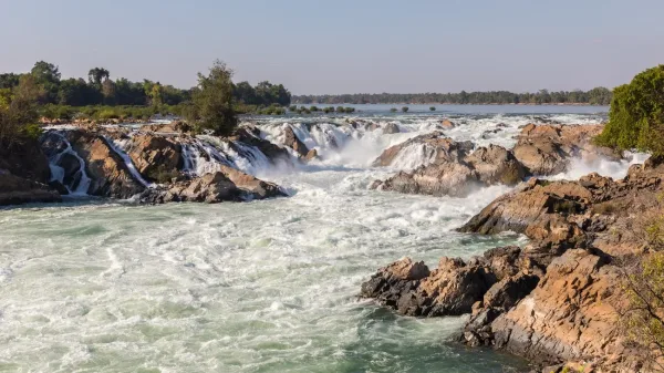
Image Source: Wikipedia
Khone Phapheng Falls stands as a natural marvel on the Mekong River. This massive cascade system ranks among the world’s most powerful waterfalls, yet it remains lesser known globally. Its unique characteristics set it apart from typical waterfalls.
Khone Phapheng Falls Flow Rate
The raw power of Khone Phapheng Falls shows through its remarkable average discharge of nearly 11,000 cubic meters per second (390,000 cubic feet per second). The volume surges to over 49,000 cubic meters per second (1,700,000 cubic feet per second) during rainy seasons. With an average flow rate of 11,610 m³/s, this magnificent cascade is the fourth-largest waterfall on Earth by volume. The falls earned their place as Southeast Asia’s largest waterfall. Visitors often describe it as “pure, unrestrained aggression, as millions of liters of water crash over the rocks”.
Khone Phapheng Falls Width
The most striking feature of Khone Phapheng Falls is its breathtaking width. The falls stretch 10,783 meters (35,376 feet or 6.7 miles) from end to end, making it the world’s widest waterfall. A complex network of channels created by thousands of islands gives the area its local name “Si Phan Don” or “the 4,000 islands”. The falls feature a series of rapids that extend across 9.7 kilometers (6.0 miles) of the river’s length. The highest drops reach 21 meters (69 feet).
Khone Phapheng Falls in Asia
The falls lie in Champasak Province on the Mekong River in southern Laos, close to the Cambodian border. This powerful cascade blocks full navigation of the Mekong River into China. The water “transforms the easily navigable Upper Mekong into a muddled six-mile wide raging torrent”. Nature created this barrier that protects the river’s upper reaches.
The falls support an amazing ecosystem. The endangered plabuck, known as the world’s largest freshwater fish, calls these waters home. The critically endangered Irrawaddy dolphin shares this habitat with a rare species of hillstream loach, nicknamed “lizardfish”.
Pará Falls

Image Source: AMAZON WATERS
Pará Falls (Salto Pará) shows nature’s raw power through its isolation and impressive hydraulic force. This Venezuelan giant sits in one of South America’s least available regions. The falls are evidence of the continent’s amazing water wonders, yet most tourists never see them.
Pará Falls Flow Rate
The falls command respect with an average flow rate of 3,540 cubic meters per second (125,000 cubic feet per second). The volume swells to 5,608 cubic meters per second (198,000 cubic feet per second) during seasonal floods. These numbers make it the fifth most powerful waterfall worldwide based on average discharge volume. The concentrated flow makes these statistics remarkable. The entire volume rushes through just five distinct cataracts, which creates tremendous pressure at each drop point.
Pará Falls in South America
The falls stand as the largest extant waterfall in South America by average flow rate. Located in Venezuela at coordinates 6°19′01″N 64°30′33″W, this natural wonder remains untouched compared to other available cascades on the continent. Water plunges about 75 meters (246 feet) from top to bottom, creating a spectacular display of raw power. All the same, the falls stay relatively unknown because of their remote location, unlike their famous continental neighbors like Iguazú Falls.
Pará Falls River System
The Caura River creates Pará Falls before joining the Orinoco River system. This river serves as a vital tributary in Venezuela’s network. Visitors must take a long boat trip to see this natural spectacle since the falls lie 110 kilometers from the nearest road. The isolation has protected both the falls and surrounding ecosystems. Water drops through five distinct cataracts, each adding to the total 75-meter height. The surrounding landscape stays pristine because boats provide the only access. This offers rare glimpses of untouched Venezuelan wilderness that few outsiders ever see.
Paulo Afonso Falls

Image Source: Wikipedia
Paulo Afonso Falls exemplifies how human engineering has substantially altered Brazil’s natural wonders. The São Francisco River’s series of rapids and three cataracts at the Bahia-Alagoas border in northeastern Brazil demonstrates nature’s raw power and our ability to adapt it for our needs.
Paulo Afonso Falls Flow Rate
The falls’ natural state showed an average water discharge of 2,832 cubic meters per second (100,000 cubic feet per second) before human intervention. This made it one of the world’s most powerful waterfalls. The falls reached peak flows of at least 14,158 cubic meters per second (500,000 cubic feet per second), making it Brazil’s largest waterfall by volume. Its impressive 84-meter height (276 feet) combined with a narrow width of less than 60 feet (18 meters) created tremendous force as water rushed through the gorge.
Paulo Afonso Falls Hydroelectric Regulation
The São Francisco River’s natural flow has changed due to extensive damming for hydroelectric power. The Hidrelétrica de Angiquinho became northeastern Brazil’s first hydroelectric power station in 1912, built upstream of the falls. The Paulo Afonso Hydroelectric Complex construction began in 1948, which changed the falls’ natural character forever.
The complex utilizes the falls’ natural 80-meter (260 ft) gap and has multiple controlled spillways. A reservoir with 1.2 billion cubic meters capacity and 100 square kilometers surface area sits behind the main dam. The Sobradinho reservoir adds 29.4 billion cubic meters of usable storage capacity to the system. The falls now serve as a natural spillway during high rainfall years. Visitors can still experience the falls’ former magnificence when operators open the dam’s flood gates at certain times.
Niagara Falls

Image Source: Niagara Action
Niagara Falls stands as North America’s most renowned waterfall, uniquely combining tremendous hydroelectric capabilities with extraordinary tourist appeal. This magnificent cascade, which spans the border between the United States and Canada, showcases both natural splendor and industrial utility.
Niagara Falls Flow Rate
The sheer power of Niagara Falls becomes evident through its remarkable discharge rate, averaging 2,400 cubic meters per second (85,000 cubic feet per second). The volume swells to more than 168,000 cubic meters (5.9 million cubic feet) of water rushing over the crestline every minute during peak tourist seasons. Horseshoe Falls commands 90% of this water flow, while American and Bridal Veil Falls share the remainder. Authorities carefully regulate the water flow. They reduce it to 50% at night and during winter months but manage to keep a minimum flow of 1,400 cubic meters per second (49,000 cubic feet per second).
Niagara Falls Tourism
The falls serve as an economic powerhouse through tourism. Visitor spending in Niagara Falls, Canada reached USD 2.10 billion in 2023, which created a total economic effect of USD 3.10 billion including indirect benefits. The American side’s Niagara County generated over USD 1.00 billion in tourism revenue during 2023. Niagara Falls State Park alone draws more than 8 million visitors each year. These tourists come to witness the spectacular sight of 3,160 tons of water cascading over the precipice every second.
Niagara Falls Hydroelectric Use
The falls’ tremendous energy has powered electricity generation since 1881. Canadian power stations use up to 56,500 cubic feet of water per second, while American facilities utilize 32,500 cubic feet per second. The Niagara Power Project channels 748,000 gallons of water per second through 25 turbines to generate up to 2.6 million kilowatts of clean electricity. The 1950 Niagara River Water Diversion Treaty governs water usage. This agreement ensures the preservation of scenic beauty by requiring minimum flows of 100,000 cubic feet per second during tourist season daytime hours and 50,000 cubic feet per second during off-peak periods.
Iguazú Falls
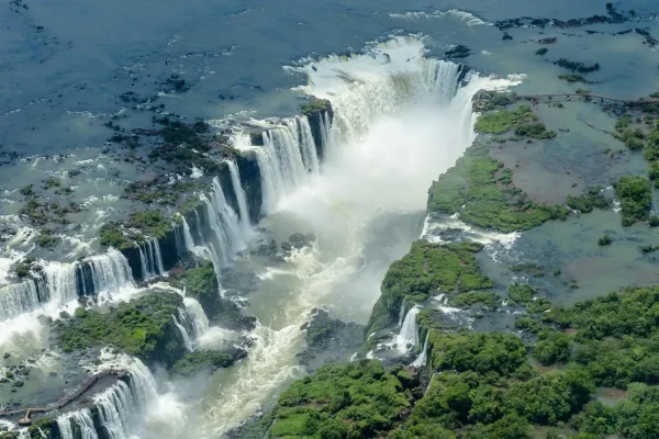
Image Source: Wikipedia
Iguazú Falls stands as a magnificent natural marvel where Argentina meets Brazil. These cascades create one of the world’s largest waterfall systems. The sheer power and width of this natural wonder left such an impression on Eleanor Roosevelt that she famously exclaimed, “Poor Niagara!”
Iguazú Falls Flow Rate
The falls roar with an average flow rate of 62,010 cubic feet per second (1,756 m³/s). This ranks them as the world’s sixth most powerful waterfall by volume. The rainy season from November to March brings a dramatic surge, reaching up to 450,000 cubic feet (12,750 m³/s) per second. February typically sees the highest flow rates. Niagara Falls has a higher average flow at 85,000 cubic feet per second, but Iguazú’s extraordinary width and multiple channels spread the water across many individual falls.
Iguazú Falls System
Water levels determine the number of individual waterfalls, which can range from 150 to 300. The falls create a semicircular spectacle that stretches 1.7 miles (2.7 km) along the Argentina-Brazil border. These cascades drop between 197 feet (60 m) and 269 feet (82 m). The most impressive section, known locally as Garganta del Diablo (Devil’s Throat), plunges 269 feet (82 m). The falls emerged where the Paraná Plateau meets lower basaltic rocks along a geological fault line. This created the dramatic 80-meter vertical drop that defines the system. The river’s name comes from indigenous words meaning “great water”, and it forms a massive horseshoe bend at the falls.
Iguazú Falls UNESCO Status
UNESCO recognized the falls’ significance in two phases – first the Argentine side in 1984, then the Brazilian portion in 1986. The designation celebrates their “exceptional natural beauty” with 275 cascades creating massive water sprays. The protected area serves as a vital sanctuary for the endangered Atlantic Forest ecosystem. The region teems with life, housing over 2,000 plant species, 400 bird species and about 80 mammal species. Rare creatures like jaguars, giant otters, and broad-snouted Caimans call this place home. The falls earned another prestigious honor when they were named one of the New Seven Wonders of Nature in 2011.
Victoria Falls

Image Source: Wild Wings Safaris
Victoria Falls thunders as nature’s grand spectacle where the Zambezi River plunges into a narrow chasm. This UNESCO World Heritage Site straddles Zambia and Zimbabwe. Many people call it the world’s largest sheet of falling water because of its extraordinary width and height.
Victoria Falls Flow Rate
The falls boast a mean annual flow rate of 1,088 cubic meters per second (38,430 cubic feet per second). Water flow changes throughout the year. Peak season hits between March and May when more than five hundred million cubic meters of water crash over the edge every hour. The dry season tells a different story. November sees the lowest levels at 100-300 cubic meters per second. The Zambezi River’s flow at Victoria Falls jumped from 349 m³/s in early January 2020 to 3,890 m³/s by late March 2020. This is a big deal as it means that the flow was 54 percent above the recorded long-term average. The falls’ yearly average flow rate looks lower than expected because seasons change so much.
Victoria Falls Width and Height
Victoria Falls creates the world’s largest curtain of falling water with its impressive width of 1,708 meters (5,604 feet) and height of 108 meters (354 feet). The falls has sections that each tell their own story: Devil’s Cataract (70m high), Main Falls (93m high), Horseshoe Falls (95m high), Rainbow Falls (108m high) and the Eastern Cataract (101m high). Mist from the falls shoots up over 400 meters (1,300 feet), sometimes reaching twice that height. People can see this spray from up to 50 kilometers away. North America’s Niagara Falls stands at half the height of Victoria Falls.
Victoria Falls Nickname
“Mosi-oa-Tunya” means “The Smoke that Thunders”. This local name captures the falls’ most striking feature – massive spray columns visible from miles away. The Kalolo-Lozi people gave the falls this name. Other tribes had their own names: Shungu na mutitima (southern Tonga), aManz’ aThunqayo (Matabele), and more – all meaning “the smoke that thunders”. Scottish explorer David Livingstone named the falls after Queen Victoria in 1855. He found a prominent natural wonder that local people already revered for its thunderous roar and rainbow-filled mist.
Shivanasamudra Falls

Image Source: Karnataka.com
The majestic Shivanasamudra Falls splits the Kaveri River in Karnataka, India. This natural wonder features a unique twin-waterfall system that demonstrates raw natural power. These spectacular cascades stand among Asia’s most powerful waterfalls, with the river dividing around an island to create two distinct yet connected marvels.
Shivanasamudra Falls Flow Rate
Shivanasamudra Falls’ immense power comes from its average flow rate of 934 cubic meters per second (33,000 cubic feet per second). This volume places it among the world’s most powerful waterfalls. The maximum recorded flow rate reaches 18,887 cubic meters per second (667,000 cubic feet per second) during extreme floods. The falls reach their peak grandeur from July to October. The monsoon season brings thunderous roars that inspired the name “Lord Shiva’s sea”. The falls stretch 305 meters (1,001 feet) wide and plunge 98 meters (322 feet).
Shivanasamudra Falls Twin Structure
The Kaveri River’s split around Sivasamudram Island creates two main waterfalls—Gaganachukki and Bharachukki. Each waterfall has its unique character. Gaganachukki towers 90 meters high with two major segments that form a horseshoe shape. Bharachukki reaches 69 meters and cascades over multiple steps in a wider formation. These falls are not different parts of one waterfall. The river splits several kilometers upstream into western and eastern branches. The western branch creates Gaganachukki’s twin falls, while Bharachukki forms from the eastern branch. Visitors can view these falls from points that sit 15 kilometers apart. The falls rank among the world’s top 100 waterfalls. They also house one of Asia’s first hydroelectric power plants, a 120-year old facility built in 1902.
Murchison Falls

Image Source: Kahuzi Biega National Park
Murchison Falls stands as a remarkable hydrological marvel in Uganda’s largest national park. The mighty Victoria Nile forces its way through an impossibly narrow gap, making it one of the world’s most powerful waterfalls. This spectacular cataract demonstrates nature’s raw hydraulic force.
Murchison Falls Flow Rate
The Victoria Nile roars through Murchison Falls at approximately 300 cubic meters per second (11,000 ft³/s). While its volume seems modest compared to other waterfalls, its extraordinary concentration makes it unique. The river channel spans about 50 meters upstream but narrows dramatically to just 7 meters (23 ft) at the falls’ crest. All water squeezes through this tight gap before plunging 43 meters (141 ft) below.
Murchison Falls Power
The falls’ compressed power generates such force that it makes the surrounding ground shake. A thunderous roar and constant rainbow-laden mist have earned the falls a local reputation as a site of raw, elemental power. The water pressure through the gorge reaches extreme levels. Every second, water equivalent to 200 bathtubs rushes through a gap barely seven paces wide. The water then transforms into a peaceful flow as it meanders toward Lake Albert.
Murchison Falls Boat Cruise
Boat cruises from Paraa give visitors exceptional views of the falls’ magnificence. These popular two-hour trips guide passengers 17 kilometers upstream to the falls’ base, showcasing both wildlife and the waterfall’s grandeur. Visitors often spot large Nile crocodiles, hippo pods, and various birds including kingfishers and fish eagles. The powerful currents create visible foam islands, showing evidence of trapped plants and animals. Daily cruises run between 8:00-9:00am and 2:00-3:00pm. Photographers prefer afternoon trips for better lighting conditions.
Willamette Falls

Image Source: Wikipedia
Willamette Falls stands as North America’s hidden hydraulic wonder between Oregon City and West Linn. This natural marvel ranks among the world’s most powerful waterfalls, yet remains in the shadow of its more famous counterparts. The horseshoe-shaped cascade shows its mighty force through its massive flow volume and impressive width.
Willamette Falls Flow Rate
The raw power of Willamette Falls comes from its massive average flow rate of 30,850 cubic feet per second (874 cubic meters per second). This makes it the largest waterfall by volume in the Northwestern United States. Water levels change with the seasons, and kayakers report very different experiences between 14,200 and 40,000 cubic feet per second. Most experienced paddlers hit the falls when flows reach 30,000-40,000 cubic feet per second and standing waves form on the river’s right side under specific conditions. The area becomes too dangerous for kayakers when flows push past 40,000 cubic feet per second. Strong currents, boils and water flowing in multiple directions make navigation challenging even at lower flow rates.
Willamette Falls Historical Width
The falls’ most striking feature is its massive span. Most historical measurements put the falls’ width at about 1,500 feet (455 meters), making it the seventeenth widest waterfall in the world. Some sources give slightly different numbers – from 1,300 feet to 1,600 feet across. The falls’ huge width and 42-foot height create a water curtain you can see from far away. The falls took shape as a horseshoe-shaped block waterfall, formed by a basalt shelf in the river bottom. This created the curved formation we see today.
Virginia Falls
Deep in Canada’s Northwest Territories wilderness, Virginia Falls (Nailicho) stands as a breathtaking display of water power that amazes even experienced waterfall enthusiasts. This magnificent waterfall towers at twice Niagara Falls’ height and remains untouched in its natural glory.
Virginia Falls Flow Rate
The falls push through an average of 1,000 cubic meters per second (35,000 cubic feet per second), making it one of the world’s most powerful waterfalls. Each day, about 100 million tons of water crash over these falls. Summer brings dramatic increases in water flow as mountain snow melts and the flow usually peaks in June. Heavy rains from July through September often cause flash floods that increase the falls’ already massive volume. Visitors hear the thunderous roar getting louder as they get closer. The mayor of Niagara Falls called it an exceptional sensory experience.
Virginia Falls Location
The falls sit in Nahanni National Park Reserve, 500 meters (1,600 feet) above sea level, about 120 kilometers (75 miles) from the Yukon border. Water plunges down a 96-meter (315-foot) vertical drop across its 850-foot (259-meter) width. The South Nahanni River’s entire volume squeezes through the notorious Sluicebox rapids after this massive drop. Visitors mainly access this remote natural wonder through the Virginia Falls Water Aerodrome, just 1,300 feet upstream.
The Dené people found these falls first and named them “Nailicho,” which means “big water falling”. Virginia Falls sits at the heart of Nahanni National Park—UNESCO’s first World Heritage site. The park covers 30,000 square kilometers of protected Canadian wilderness that remains largely untouched by humans.
Dettifoss

Image Source: Wikipedia
Dettifoss’s raw elemental force makes it one of Europe’s most remarkable waterfalls and shows evidence of Iceland’s geological power. This thunderous cascade cuts through Vatnajökull National Park’s volcanic landscape and creates a spectacle that draws visitors to the harsh yet captivating wilderness of the Icelandic north.
Dettifoss Flow Rate
Europe’s most powerful waterfall, Dettifoss, maintains an average flow rate of 193 cubic meters per second. The volume increases dramatically to about 400 cubic meters per second during peak summer periods and can reach 500 cubic meters per second in extreme conditions. The water’s sheer power generates vibrations that people can feel by touching nearby rocks. Water drops 44-45 meters vertically across a 100-meter width and erodes the cliff edge by about half a meter each year.
Dettifoss in Iceland
The waterfall sits along North Iceland’s Diamond Circle tourist route, creating a scenic circuit with Húsavík, Ásbyrgi Canyon and Lake Mývatn. Visitors need to travel 330 miles from Reykjavík to reach this natural wonder, making it a weekend destination for those who want to explore Iceland’s remote northern regions. Jökulsá á Fjöllum, Iceland’s second-largest river at 206 kilometers, feeds Dettifoss with water from Europe’s largest ice cap—Vatnajökull glacier. The glacial meltwater flows through Jökulsárgljúfur canyon and ends up reaching the Greenland Sea. Glacial origins give the waterfall its distinctive milky, sediment-rich appearance, which contrasts with the gray-colored rock foundation. The area has remained protected since 1945 as part of Jökulsárgljúfur National Park, which now belongs to the larger Vatnajökull National Park.
Kaieteur Falls

Deep in South America’s pristine rainforests lies Kaieteur Falls, a natural marvel that combines stunning height with massive water volume. This spectacular waterfall remains untouched by commercial development.
Kaieteur Falls Flow Rate
The waterfall’s average flow rate reaches 663 cubic meters per second (23,400 cubic feet per second), making it one of the world’s most powerful waterfalls. The wet season brings dramatic increases in water volume. Visitors say the water looks like it’s “falling from the edge of the world”. The water’s raw power creates thunderous sounds that echo through the surrounding rainforest. Most waterfalls excel at either height or volume, but Kaieteur’s unique blend of both qualities sets it apart among Earth’s hydrological wonders.
Kaieteur Falls Drop
The waterfall’s main plunge stretches 741 feet (226 meters). This height towers 4.5 times above Niagara Falls and doubles Victoria Falls’ height. Water crashes down a sandstone and conglomerate cliff before rushing through steep cascades. These cascades add to the total height of 822 feet (251 meters). The falls span 300 to 350 feet (90 to 105 meters) at the crest, creating a massive water curtain visible from far away.
Kaieteur Falls in Guyana
The falls sit on the Potaro River in central Essequibo Territory inside Kaieteur National Park, a 93-year-old protected area. Guyana’s Amazon rainforest surrounds this natural wonder, keeping it wonderfully isolated. The Potaro River continues past the falls until it meets the Essequibo River, Guyana’s longest waterway and South America’s 34th longest river. Europeans first discovered the falls in 1870, and despite its remote location, it remains a popular tourist destination.
Comparison Table
| Waterfall | Average Flow Rate (m³/s) | Maximum Flow Rate (m³/s) | Height (m) | Width (m) | Location |
|---|---|---|---|---|---|
| Inga Falls | 25,768 | 70,800 | 96 | 4,023 | Democratic Republic of Congo |
| Livingstone Falls | 42,000 | – | 260 | 300-800 | Democratic Republic of Congo |
| Boyoma Falls | 16,990 | – | 61 | – | Democratic Republic of Congo |
| Khone Phapheng Falls | 11,610 | 49,000 | 21 | 10,783 | Laos |
| Pará Falls | 3,540 | 5,608 | 75 | – | Venezuela |
| Paulo Afonso Falls | 2,832 | 14,158 | 84 | 18 | Brazil |
| Niagara Falls | 2,400 | – | – | – | USA/Canada |
| Iguazú Falls | 1,756 | 12,750 | 82 | 2,700 | Argentina/Brazil |
| Victoria Falls | 1,088 | – | 108 | 1,708 | Zambia/Zimbabwe |
| Shivanasamudra Falls | 934 | 18,887 | 98 | 305 | India |
| Murchison Falls | 300 | – | 43 | 7 | Uganda |
| Willamette Falls | 874 | – | 13 | 455 | USA |
| Virginia Falls | 1,000 | – | 96 | 259 | Canada |
| Dettifoss | 193 | 500 | 44 | 100 | Iceland |
| Kaieteur Falls | 663 | – | 226 | 90-105 | Guyana |
Appreciate the Most Powerful Waterfalls in the World
Raw hydraulic power of nature shines through these fifteen remarkable waterfalls with their exceptional flow rates. Inga Falls and Livingstone Falls lead the pack, showing staggering discharge volumes that exceed 25,000 and 42,000 cubic meters per second. All the same, waterfalls with smaller flow rates like Murchison Falls display extraordinary power by forcing entire rivers through gaps only seven meters wide.
Flow rate tells just part of the story when we look at these natural wonders. Khone Phapheng Falls ranks fourth by volume but stands as the world’s widest waterfall at nearly 11 kilometers across. Kaieteur Falls combines substantial flow with a 226-meter plunge that towers over both Niagara and Victoria Falls. Each waterfall has unique characteristics that set it apart – from geological formation to cultural significance and hydroelectric potential.
These powerful waterways play a crucial economic role. Niagara Falls brings in billions in tourism revenue each year while producing massive amounts of clean electricity. Sites like Inga Falls remain mostly untapped resources that could power much of the African continent. These waterfalls serve as both natural spectacles and vital energy resources for future generations.
These thundering cascades have shaped how humans settle, created cultural traditions and sparked technological advances through history. The Wagenia people created specialized fishing techniques just for Boyoma Falls. Modern engineers now employ Paulo Afonso Falls to power millions of homes. While dams and flow regulation have changed many of these waterfalls, their fundamental power continues to engage visitors and inspire awe.
Without doubt, flow rate offers just one way to understand these hydrological marvels. Volume, height, width and geological setting combine to create fifteen unique experiences – from Devil’s Throat’s thunderous roar at Iguazú Falls to the rainbow-filled mist that rises from Victoria Falls. These waterfalls stand as evidence of water’s relentless force and remind us how nature can both destroy and create through endless cycles of erosion and deposition.
FAQs
Q1. Which waterfall has the highest flow rate in the world?
Inga Falls on the Congo River has the highest average flow rate of approximately 25,768 cubic meters per second, making it the largest waterfall in the world by volume.
Q2. How does Niagara Falls compare to other powerful waterfalls?
While Niagara Falls is famous, it’s not the most powerful. It has an average flow rate of 2,400 cubic meters per second, ranking lower than several others like Inga Falls and Livingstone Falls.
Q3. What makes Murchison Falls unique among powerful waterfalls?
Murchison Falls is notable for its concentrated power. The entire flow of the Victoria Nile River is forced through a narrow 7-meter gap before plunging 43 meters, creating an incredibly intense waterfall.
Q4. Which is the widest waterfall among the most powerful?
Khone Phapheng Falls in Laos is the widest, spanning an impressive 10,783 meters (6.7 miles) across the Mekong River.
Q5. How do seasonal changes affect the flow rates of these powerful waterfalls?
Many of these waterfalls experience significant seasonal variations. For example, Iguazú Falls can see its flow rate increase from an average of 1,756 cubic meters per second to a maximum of 12,750 cubic meters per second during the rainy season.













Leave A Comment